CAROLYN

My Gateway to the Abrolhos and Kalbarri – Geraldton, Western Australia

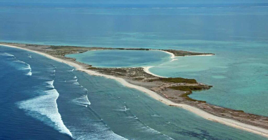
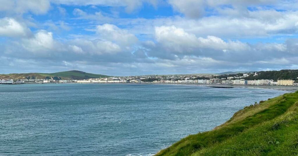
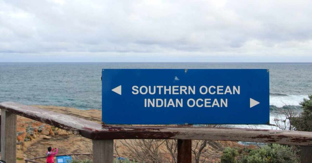
Geraldton, Western Australia – My Gateway to the Abrolhos Islands and Kalbarri I’d been in Western Australia’s capital Perth for a couple of weeks and wanted to see more of the west. It wasn’t easy picking out-of-town excursions. Western Australia is huge, and east, south, north – each direction is so different from the others. One place I knew I wanted to visit was Cape Leeuwin in the south, where the Southern and Indian Oceans meet. So, I took a day trip, and while it was well-organized and covered all the high spots there and back, it was a heck of a long day, especially so because we – all of us – waited an extra half hour for the return of a couple who round-tripped the Busselton Jetty’s 1.84 kilometers against our driver’s explicit instructions (that’s more than two miles out and back). Another place I visited was Guildford, a short local train ride from Perth, and a great place to stay for visiting the Swan Valley. I went twice – different years – and enjoyed the architecture, history (a docent in the Visitor Center made absolutely sure I saw all the exhibits), lovely strolls, and afternoon tea. In any case, when I decided upon Kalbarri National Park and the Houtman Abrolhos Islands for my trip northward up the coast, I chose to stay in the small city of Geraldton. Staying in smaller cities is a great way to get to know another country or state better; and it would save me loads of time going back and forth from Perth. Staying in Geraldton turned out to be a great choice. See Around Geraldton – Kalbarri National Park, Houtman Abrolhos Islands, and Hunting Wildflowers for more info about the park and islands! Geraldton is just over four hours from Perth by car or bus, or a short flight. Maps suggested all the in-town sights were walkable, so I flew and skipped the car hire. I don’t know whether this is still the case, but then, as our flight approached Geraldton, the cabin crew took a head count of passengers needing taxis. The flight crew called ahead, and the waiting taxi drivers identified us by seat number. Be attentive, and press the call button if asked, or you could be out of luck. I didn’t see another taxi until the one I’d arranged for ahead of time picked me up the day I flew back to Perth. Hailing a taxi on the street didn’t seem to be a thing in Geraldton. But it was OK; I had intended to be on foot. Still, I’ve spent plenty of time in beach towns and should have known that a town right on the coast will spread along the shore. And Geraldton does spread. So, sometimes getting around, such as to the Museum of Geraldton, or to Priceline pharmacy on my shredded toes for more Elastoplasts (adhesive bandages), was a long hike. Still, a car wasn’t essential although I could have spent more time in the places I visited than in walking there and back; but this was kind of a split decision with myself – one side of me said car, the other side said no car. We see which side won, and I did get better at plotting routes, combining visits, learning the back ways, and discovering more about Geraldton. And think of all the steps I toted up. Getting My Bearings Because I planned to visit Geraldton on foot, before leaving Perth I picked a place to stay that looked close to what I thought of as center. It was generally central, but Weelaway House was closer to one edge of center, and most of my destinations were on the other edge, up the shore. Still, I enjoyed Weelaway, a comfortable, historic house (1862) in a real neighborhood. When I arrived, check-in was DIY; I had clear instructions to access my key box as no one would be there to greet me the day I came. I found myself in a large parlor with my room just down the central hall. At Weelaway, we could make our own breakfast from bread, spreads, coffee and tea provided in the common kitchen, and we had the nice parlor for resting after a long walk, having a chat with other guests, or just getting out of your room for some space. When I met local people and they asked where I was staying, to a person they knew Weelaway. I was the only guest without a car during my stay. As other guests drove off for the day (some to their work sites – there are a lot of peripatetic people in the WA extractive industries), I slung on my backpack and tromped into town. Until I got my bearings, I found my way back home by looking for the huge date palms in the side yard. Terrace outside my room at Weelaway. Weelaway palms In any town an obvious first thing to do is go to the local Visitor Centre, which was handily toward my end of town. And it was a good start in Geraldton – the staff were energetic and helpful, offering plenty of options even for pedestrians like me. I picked up a good map, booked a flight to the Abrolhos Islands and then went off to find food. Eating Out I never investigated Geraldton’s food scene, and didn’t even eat seafood, which seems dreadful. There are good seafood restaurants, so I suggest you be more wide-ranging in your dining than I was. But I enjoyed two good places I found early on, and so stuck with them, along with Woolworth’s for groceries. After all, I had a kitchen. My first find was Café Fleur, a few blocks along Marine Terrace from the Visitor Centre. There was a crowd (good sign), and it looked comfortable. It was getting on toward early afternoon, and good thing I didn’t waste time getting there, because the café closed about the time

My Gateway to the Abrolhos and Kalbarri – Geraldton, Western Australia Read More »

Around Geraldton – Kalbarri National Park, Houtman Abrolhos Islands, and Hunting Wildflowers

Around Geraldton – Kalbarri National Park, Houtman Abrolhos Islands, and Hunting Wildflowers During a stay in Western Australia’s capital Perth, I decided to visit Kalbarri National Park and the Houtman Abrolhos Islands, farther up the coast than other places I wanted to see. Turns out both are close to the small city of Geraldton. Why not stay there for a few days? It would save time going back and forth from Perth, and Geraldton would be another place with its own sights to see and new people to meet. Plus, it was wildflower season, and Western Australia’s wildflowers are renowned and plentiful up that way. See Geraldton, Western Australia – My Gateway to the Abrolhos Islands and Kalbarri for more info about the town! As soon as I set my sights on Geraldton, I planned to be car-free so looked for local tours. A bit of hunting followed by a visit to the Geraldton Visitor Centre got me booked on a day trip to visit Kalbarri National Park and sights along the way, and on another day’s wide-ranging wildflower tour. Also at the Visitor Centre, I booked a flight to the Abrolhos Islands, a fly-over with touchdown for a ramble and morning tea on East Wallabi Island. Houtman Abrolhos Islands Don’t miss the Abrolhos Islands, whether you travel there from Geraldton, Perth, or somewhere else. The islands combine exquisite beauty with world-class nature and a film-worthy history that includes the infamous wreck of the Dutch East India Company merchant ship Batavia in 1629, and the massacre of most survivors by deranged Company officer Jeronimus Cornelisz. Learn more about the Batavia here. Today, the waters around the Abrolhos are still pristine (so get there before the cruise ships begin stopping) with an abundance of marine, terrestrial, and avian life that’s covered in this Department of Fisheries booklet. The booklet also includes information on geology, history, shipwrecks, and today’s commercial rock lobster fishery. Flying to the Abrolhos Islands Baby Abrolhos dwarf bearded dragon My flight in our four-seater with pilot Martin was brilliant, so consider a flyover if you don’t have time for a longer excursion. In the clear water below, we saw dolphins, sharks, humpback whales, and the biggest manta ray that Martin had ever seen (it was huge!). We watched a humpback mother and her calf, lazing in the warm water, getting some R & R during their migration south. We flew over Batavia sites, including the visible shape of the sunken ship, and remnants of a rudimentary fort built by a group of massacre escapees. On East Wallabi for our picnic morning tea, we watched birds and skittering lizards and skinks, but I wanted most to see an Abrolhos dwarf bearded dragon. Martin went out on the hunt and found a baby that sat still for several photos before disappearing into the scrub. Kalbarri National Park Kalbarri is “big nature” – high coastal cliffs washed by the Indian Ocean, the Murchison River gorge, Nature’s Window (not that easy to get your picture here without being photo bombed). Some of the trails we took are over rocks, so good shoes and caution are advised. We followed the long curve of the coast, stood high over the Murchison and made out the gray kangaroos lying in the shade way below, walked into fields of endemic, cottony-feeling smoke bushes. (I wore boots in case I encountered snakes.) Through Nature’s Window Kalbarri cliffs Smoke bush wildflowers Pink Lake Pelicans waiting for a handout I liked the long day’s ride in our outback-suitable van. It was the very beginning of the season, and the only other guests were two delightful sisters from Hong Kong. On a springtime Kalbarri trip there’s also the opportunity to see the park’s wildflowers. There’s more on wildflowers just below, but along with grand nature, Kalbarri Park had masses of wildflowers, diverse in family, size, and color. Along the way, we also stopped at Pink Lake where we walked along the shore for a while. The lake is improbably pink thanks to a particular alga, but the color may vary depending on the weather and seasonal changes. I saw the famous bubble gum color.  And when we stopped for an outdoor lunch in the little town of Kalbarri, I got my first look into a pelican’s gullet. It wasn’t on my must-see list but there it was, the birds begging for a fisherman’s handout. Wildflower Hunt Even if you think you’re not a wildflower fancier, it would be a shame to miss one of the greatest displays of wildflowers on earth. Western Australia has around 8,000 native plants and up to 85 percent of southwestern WA wildflowers are endemic and grow nowhere else. Once again, I went out with a local tour, and our small group that day enabled us to get into the bush and look for the unique. One location not to be missed is the Coalseam Conservation Park, between Mullewa and Mingenew. There you’ll find – yes – a visible coal seam, along with carpets of everlastings that make great cover photos on wildflower pamphlets. We had a bit of a ramble there, and while the everlastings are most attention grabbing, there are scores of other flowers. Our guide was especially good at scouting out hidden species, and we stopped periodically to look for, and find, the rare. I don’t recall the names of all the flowers, but I have many photos, and did bring home quite a few wildflower books should I be seized with the desire to identify them. Or perhaps I’ll just enjoy looking at the pictures. Everlastings at Coalseam More everlastings I have a lot of affection for tiny orchids and kangaroo paws, but my favorite was the wreath flower. Once again, our guide knew the dirt roadsides in Murchison Shire where they flourish in disturbed, sandy soil. Being in Murchison Shire was itself an event of sorts for me. The Shire has a population of about 113, mostly on family-run cattle

Around Geraldton – Kalbarri National Park, Houtman Abrolhos Islands, and Hunting Wildflowers Read More »

Getting Acquainted with One Family Root – Isle of Man

Getting Acquainted with One Family Root – Isle of Man I’ve never much gotten into searching for my roots but have nearly always been aware of Isle of Man because even as kids we knew that an ancestor came from there, in the 1700s, it’s true, but to me there was still the mystique of “being Manx.” By the time I came along, our Manxness was well-diluted, but the idea remained. So, finding myself with some free time during a stay in Ireland, I decided to take the short flight to Isle of Man and finally connect with the old turf. BBC Online cited Isle of Man as a place to go in 2025, with gorgeous scenery, self-guided and guided walks, and a density of ancient sites to explore. Committed stewardship is important to maintaining this beauty: the entire island and its surrounding waters have been designated a UNESCO Biosphere, for its natural beauty, stewardship, and rich cultural heritage. I’d like to do some of that walking and exploring, but in April 2024, I just wanted to see what I could on a weekend, sort of a get-acquainted trip. And although not searching for roots, I did want to learn more about our Manx family. To Town from the Airport – by Bus. When I got to Ronaldsway Airport after the half-hour flight from Dublin, I went looking for a taxi. None showed up, and I heard people say that it would be unlikely for a taxi to just appear. So, I piled on the next bus with the other Dublin arrivals, including a group coming for a fun weekend – they had clearly started having “fun” back in Dublin. As to bus stops in town, our driver wasn’t very talkative, but a grizzled regular rider knew where all the hotel stops were, so he announced enthusiastically to us plane passengers when we each got to ours. The bus stopped in front of my hotel, and it was so easy to manage that I bused back to the airport after my weekend. I stayed at the re-done Halvard Hotel on Douglas Promenade. The promenade is a couple of miles long, with blocks of Victorian facades that look a lot alike. So, if you choose to stay along there, get to know the visual clues that tell which one is home. There are names and numbers, sure, but some of us are very visual. Douglas from across the bay, Isle of Man. When I checked in at the Halvard, the upbeat guy at reception booked me into the hotel restaurant which was serving only me and a local couple early on that off season evening. While the man talked volubly on his phone, his wife turned around 180 degrees to talk to me until her dessert arrived. The sea view was pretty. A ferry was leaving the Sea Terminal on a bright, blustery evening. Otherwise, it was quiet in the harbor. A Diversion for Some History – The Tynwald. This isn’t a civics lesson, but it’s worth taking a moment to talk about the Manx parliament, The Tynwald, which is over a thousand years old. The Tynwald website says it’s the oldest parliament in the world that has been in continuous operation. Iceland’s parliament, the Althing, is slightly older but hasn’t “operated continuously throughout its history,” they say. Every July there’s an open-air meeting of parliament on Tynwald Hill in St. John’s; Manx law requires that each Act of Tynwald must be promulgated on Tynwald Hill within eighteen months of enactment, or it ceases to have effect. So, there’s that to do, then take petitions for redress, and complete other business. It’s a serious and festive affair with much color and pageantry. The rest of the time, Tynwald meets indoors in Douglas. First task: Getting to Know You, Isle of Man – Driving Around the Island with Guide Jane I knew that I wanted to see Maughold, from where my best information says our ancestor departed for North America. Then, I wanted to see some towns and historic sights. I got in touch with Jane, a local guide, who said that in half a day, we could drive around the north of the island, visit Maughold and Ramsey, then cross over to Peel, with frequent stops. We’d drive within sight of Snaefell and along part of the TT [motorcycle] Races route, too. Jane’s knowledge of Manx families and history also promised that I would learn a lot. The Great Laxey Wheel Laxey River by the woolen mill Laxey Woolen Mills King Orry’s Grave, Laxey King Orry’s Tomb Site, Laxey Laxey – A Big Wheel, a Woolen Mill, and an Old Tomb. The Great Laxey Wheel is Isle of Man’s most iconic landmark and the world’s largest working water wheel. At 72 feet and six inches in diameter (about 22 meters), it represents an extraordinary feat of Victorian engineering – it had to be big to pump flood water from the 2,200-foot deep, 4,000-foot long (about 671 meters deep and 1220 meters long) Great Laxey Mine. There’s a lot to see, including from a viewing platform 95 spiral steps up, and underground tours in season. It started to rain, sparing me the 95 steps. The wheel is a marvel, but to me the real story was the mining on the island, about which I knew nothing. The Great Laxey Mine, sunk in 1780, produced zinc, lead, and copper. At its height, the mine produced half of Britain’s zinc ore output. Accidents and miner deaths were common. The Great Laxey Mine closed in 1929, ending mining on the island. Laxey Woolen Mills was founded in 1881 to promote and preserve the weaving of traditional Manx tweed and worsted. The mill still operates and is the only mill in the world weaving genuine Manx Loaghtan cloth and tweed in pure undyed Manx wool. This visit was interesting for its social and industrial history, as well as its lovely location by the Laxey River. The

Getting Acquainted with One Family Root – Isle of Man Read More »

Singapore Impressions – Going Once, Going Twice

Singapore Impressions – Going Once, Going Twice In 2019, my travel friend Kathy and I built a DIY trip to Asia, starting in Shanghai and including Singapore, a multicultural city with an interesting history, clean to the point chewing gum was regulated, and home to the famous Marina Bay Sands Resort, with its unique architecture and rooftop infinity pool, and to Changi airport with its indoor waterfall. We arrived with plans; I also arrived with a lung infection (not Covid) that I’d picked up somewhere between home, Shanghai, Hong Kong, and Singapore. Luckily, I was flat out only the last day and wound up in a clinic at our next stop, Cambodia, where everyone was capable and kind. But that’s another story. This did slow down both of us in Singapore, though. In any case, with only about three days to explore Singapore and with me incapacitated for a day, we left town with things yet to do, and planned to meet up there again, which we did in early 2024. As with other big places I visit, this isn’t a travel guide, but it’s my story about some of the things that enriched those days in Singapore. The rest can be filled in easily with guidebooks and online research. A Five-Sentence History for a Starter The island of Singapore has been a trading outpost for millennia. Perhaps what we think of as “modern” Singapore dates from 1819 when the British arrived, and Sir Stamford Raffles established a trading post for the British East India Company. Trade boomed especially after the Suez Canal opened. After World War II and Japanese occupation, Singapore was first British again, then became part of the new Federation of Malaysia in 1963, and in 1965 seceded from Malaysia, becoming the independent city-state that we know today. It has long been a multicultural society, with four official languages, Malay, Mandarin, Tamil and English, and most citizens are at least bilingual. Traffic congestion also happens in the waterways with trade ships. More Fives: The Five-Footway – Shelter from the Elements This is a short digression because we found the footways a great relief from end-of-monsoon rains in 2024. Stamford Raffles’s town plan included the footways, created by requiring street-level shophouses to be set back five (or so) feet from the street, with upstairs living quarters extending out as far as the curb. This went for public buildings as well, and created a type of “veranda,” originally intended to protect pedestrians from the tropical sun, a sudden downpour, and the dangers of the street. As you would expect, the verandas soon filled with vendors, food hawkers and assorted others, making the footways sometimes chaotic and unsanitary, a long-lasting, contentious issue. There’s a good article on the Biblioasia website (“Give Me Shelter: The Five-footway Story,” Oct-Dec 2019). Around Tiong Bahru where we stayed there are five-footways and modern covered sidewalks, so we were able to shop, visit cafes, and reach the metro nearly entirely under shelter. The Five Footway at Monkey God temple in Tiong Bahru. The covered sidewalks in Tiong Bahru are a nice touch. You can imagine that all those food vendors in the footways became a health hazard. So, the famously clean government of the newly independent Singapore began a program of licensing and regulation, resulting in development of safe, hygienic markets and hawker centers. The hawker culture is a huge part of Singaporean life, and I have more about it in Singapore Impressions – Tiong Bahru and its Hawker Culture. Ethnic NeighborhoodsStamford Raffles had clear ideas about developing a prosperous settlement that he had gleaned from experience in British and European colonies in Asia (Java, for example), emphasizing communal harmony and ease of trade. In his vision, that town plan would allocate land to each segment of society: government, Europeans and merchants, Chinese, Malays, and Indians. These fundamental divisions exist today, and visiting each neighborhood to see its temples, parks, markets, and businesses is probably on most first-timers’ agendas. Our Visits – Zipping Around; a Non-Chronological Account Before I continue with my favorites, here is an overview of our days in Singapore. We got around on foot and by metro. Singapore has a well-developed underground, clean, fast and extensive. We bought transit cards from dispensers, like in Washington, DC, Paris, and other cities. Easy. The first day in Singapore, back in 2019, we began with a visit to the Singapore Botanic Gardens. The gardens date from 1859 and if you like gardens, Kew Gardens near London, for example, this garden is well worth visiting. It’s the only tropical botanic garden on the UNESCO World Heritage list, and one of only three listed gardens (with Kew that I’ve mentioned, and the Orto Botanico di Padova, Italia, where I’ve also been). Do not confuse the Singapore Botanic Gardens with the Gardens by the Bay! Taking a selfie in the subway. The Chinatown Arcade. The buildings here have real charm and brilliant colors. The Sri Veerama. Temple Gold. A beautiful mosque. The next couple of days we saw the city in a hurry, zipping around by metro to Little India, with its temples and shops; Chinatown, where we saw the Buddha Tooth Relic Temple; and Kampong Gelam (the Muslim quarter), where you can follow the Heritage Trail and meet a true diversity of cultures. And I can’t neglect our stop at the Raffles Hotel Long Bar. We intended to wind up the 2019 trip by seeing the Gardens by the Bay, but my illness got the better of me at the Gardens, and I had to retreat to the hotel by taxi. The Gardens visit finally happened in 2024. When we met up in 2024, the plan included Gardens by the Bay, another stop at the Long Bar, some historic buildings in the government sector, and a sweep through places of interest we couldn’t include in 2019. The Raffles Hotel Long Bar – Home of the Singapore Sling The Raffles Hotel Long Bar is where bartender Ngiam

Singapore Impressions – Going Once, Going Twice Read More »

Singapore Impressions – Tiong Bahru and its Hawker Culture

Singapore Impressions – Tiong Bahru and its Hawker Culture Back in 2019, my travel friend Kathy and I built a DIY trip to Asia, starting in Shanghai and stopping in Singapore, a multicultural city with an interesting history, clean to the point chewing gum was regulated, and home to the famous Marina Bay Sands Resort, with its unique architecture and rooftop infinity pool, and the indoor waterfall at Changi airport. For my idiosyncratic view of Singapore, and why we came twice, see Singapore Impressions – Going Once, Going Twice. This article is a quick look at Singapore’s Hawker Culture and the Tiong Bahru neighborhood, where we stayed on each trip. I’ll start with the all-important hawker (as in food) culture. Hawker Culture In Singapore Impressions – Going Once, Going Twice, I talked about food hawkers in the context of food stalls appearing early on the five footways, those clever street-level setbacks that create walkways sheltered from sun and rain. It was inevitable that food vendors would set up there, where migrants from China, Malaysia, India, Indonesia, and elsewhere could get their home country comfort foods. Some migrants earned a living by hawking these foods, too. But it was hard to keep clean, and stalls obstructed traffic. So, the famously clean government of newly independent Singapore began a program of licensing and regulation, resulting in development of safe, hygienic markets and hawker centers. The markets weren’t haphazardly located, either. The Housing Development Board was involved in the “meticulous” planning. (Note also that there are innumerable exhortations to stay clean and polite.) Tiong Bahru Market food court with Singaporean hawker stalls and wet market. National Environment Agency (NEA) promo located in the Tiong Bahru Market food court. A view inside the Tiong Bahru Market. So many food options, so little time. Big food halls, yes, but hawker culture is more than just a collective of stalls. A great article, “The History and Evolution of Singapore’s Hawker Culture,” on the Singapore government Roots website describes hawker centers as Singapore’s community dining rooms, and in our experience, our neighborhood center at Tiong Bahru Market was our community dining room, where we mingled with local people, and sometimes shared tables – with an older couple, a group of women chatting, a young man visiting from China, or people with work IDs clipped to their shirts. Tiong Bahru Market’s hawker center is on the second floor, covered, spacious, arranged around a large courtyard, airy, open to nature and sheltered at the same time. If you’ve watched Somebody Feed Phil on Netflix, you might remember that the Singapore episode opens with Phil at a hawker center – it’s Tiong Bahru! While Tiong Bahru is my favorite, I think everyone who has gotten into the Singapore hawker culture has a favorite. There are plenty to choose from – the article I mentioned says there are 110 hawker centers around Singapore, and that the government announced in 2019 that 13 new centers would be built by 2027. So, it’s no wonder that in 2020, Hawker Culture in Singapore was inscribed as Singapore’s first element on the UNESCO List of the Intangible Cultural Heritage of Humanity. Kaya Toast and Chicken Rice There are so many cuisines and delicious, popular foods at the hawker centers that I almost hesitate to single out just two. But of course, I will. Kaya Toast is a long-time popular breakfast of toasted bread with butter and kaya jam, boiled eggs, and coffee. If you don’t know, kaya jam is coconut milk jam made with sugar, eggs and sometimes pandan leaves for more flavor. The way our kaya breakfasts proceeded was thus: our white bread was lightly toasted and spread with butter and jam. Two uncooked eggs went into a plastic pitcher, followed by scalding water to cook them. The first time, I didn’t leave my eggs in the pitcher long enough and they were underdone. Not cool. Thereafter, I left my eggs in as long as practicable, and it was much better. I brought back jam from both trips, and you can order it online.   Hainanese Chicken Rice is considered by many as Singapore’s national dish. Hainanese Chicken Rice (“chicken rice”) might be simple but is considered by many as Singapore’s national dish. It’s poached chicken and flavorful rice, maybe with some accompaniment such as cucumber and sauces. Every vendor has their own variation. I had chicken rice at Tiong Bahru Hainanese Boneless Chicken Rice, one of the seven restaurants or food stalls in Michelin’s online guide to Singapore Chicken Rice. As the guide says, the stall imply closes when the day’s chicken sells out, so come early. Tiong Bahru – Unique in Singapore Why focus on this neighborhood? We found it just by chance at first. As Kathy and I each did searches prepping for the 2019 Asia trip, we looked where we might stay in local hotels outside the tourist centers. In Singapore, that led to Tiong Bahru. So, we met up in this appealing neighborhood without knowing a lot about it except that the Tiong Bahru Market was exceptional, the community was architecturally significant, and the metro was close. We stayed at the small Nostalgia Hotel, just steps from Tiong Bahru Market, and ten minutes or so on foot from the metro station for city-wide access. In 2024 we chose to return to Nostalgia. And we’re not alone thinking that Tiong Bahru is a desirable place!   Architecture in the Tiong Bahru housing area. Starting with the architecture, Tiong Bahru is unique in Singapore. It’s the oldest housing estate in the city, very desirable today, built by the Singapore Improvement Trust (SIT) in the 1930s, in a “Streamline Moderne” style, which is based on horizontal and curved lines, aerodynamics, efficiency. Think about those classic posters for glamorous travel in the 1930s – sleek trains, airplanes, fast cars, cruise ships, always on the move – and you’ll have the idea: long lines, nautical elements, curves, heading to the future. Sleek and

Singapore Impressions – Tiong Bahru and its Hawker Culture Read More »

Montevideo, Uruguay – A New City, One Week, Not Much Free Time

Montevideo, Uruguay – A New City, One Week, Not Much Free Time Could I get a sense of place in a few days? I was in Ecuador in June 2024, and the people I met and worked with made me want to learn South American Spanish. So, I started looking at schools in several cities for an in-person jump start to learning. One thing on my mind was that not knowing much Spanish, I’d do better in a location without the frisson of risk some appealing cities presented. Stable, pleasant, important, big but not too big. And pretty. That’s how I came to choose Montevideo, and Academia Uruguay. (Another bonus: Rioplatense as well as standard Spanish usage – and I’m continuing with Academia Uruguay online.) Great choices, both of city and school. My goal was to study; but I also wanted to know where I was. I’d be in class half the time, and doing homework, too – would I leave with a sense of place, or would Montevideo be only a backdrop? I felt good in Montevideo, and in the end, got that feeling I wanted, if not a complete picture of the city, because nearly all my time was spent in the Ciudad Vieja (Old City), where Academia Uruguay is located. I also explored some adjacent neighborhoods on foot but had no time for day trips around Uruguay, or even for jaunts to the beaches, parks, and restaurants outside Montevideo’s center. But it was still wintry, anyway. So, how did that feeling of “place” evolve? I think by seeing as many culturally important sites as I could, learning how to make yerba mate (at the Academia!), talking to people, and trying to speak Spanish. I also went to a terrific concert and got to know my way around by wandering. And importantly, there was my sense of mission. In the morning, when school students went off in their uniforms, and people headed to their jobs, I also had somewhere to go. I was supposed to be in this place. I belonged here and felt like that belonging showed. Getting settled on a quiet weekend My short list of “must-sees” included the central Plaza Independencia with the heroic equestrian statue of José Artigas, the soldier and revolutionary leader regarded as the father of Uruguayan independence, and his Mausoleo located beneath the monument; Palacio Salvo; and Teatro Solis. The riverside Rambla was on the list, as was my neighborhood, Ciudad Vieja. I stayed at the Radisson Victoria on Plaza Independencia, so saw the Artigas monument as my airport ride approached the hotel. Later, ready to explore, I walked to Ciudad Vieja. It was the end of winter, quiet, with many cafés, stores, and churches closed on that sunny Saturday afternoon. If the usual flea market had set up in the morning, everyone had already packed and left. (Now, in January 2025, my teacher said the city’s full of tourists, with three cruise ships in.) But following the principal street, Sarandí, brought me to the pedestrianized Calle Pérez Castellano that leads to the Mercado del Puerto, the old port market building, which was hopping with parrillos grilling up asados and filling the market with blueish smoke, buzzing with cacophonous conversations, and pleasantly crowded on both Saturday afternoon and on Sunday. Outside near the Mercado and up the street, the sun was shining, cafes were full, and the mood was happy. I enjoyed walking and looking but, in the end, ate at my hotel. Equestrian statue of José Gervasio Artigas in Montevideo Uruguay First, though, I stopped in Ciudad Vieja’s central and oldest square, Plaza Matriz (Plaza de la Constitución) where trees were still bare and the big fountain under repair. Enough people to be congenial, but no crowds. It’s a lovely place in summer; my teacher showed me pictures. At the smaller Plaza Zabala nearby, I found families out together, kids playing, and an appealing busker with a repertory from classical guitar to crooner songs. A tranquil weekend. Then on Monday I started classes.   Seeing the Top Sights I was off season, so had to watch opening times carefully. Still, I saw the most important sites, and walking along the riverside Rambla was always a sure thing. There are also dedicated, green-colored bike lanes if you fancy a bike trek. Getting to Plaza Independencia and the Artigas monument from the hotel was via a zebra crossing. I’m familiar with them but another North American I met agreed that they were a little scary in Montevideo. Traffic does stop – have courage! But back to Artigas, the Mausoleo below the plaza is part of the memorial. It’s a big, airy space that houses Artigas’s remains in a large urn guarded by members of Blandengues de Artigas, an army cavalry regiment charged among other things with certain ceremonial duties. They have great uniforms, too, and once coming back from class I saw a changing of the guard accompanied by the regimental band. Impressive. The Mausoleo is free, and I’ve seen that it’s open until five in the afternoon (17:00), but it varied when I was there in winter. You can always come another time if the heavy chain is across the stairs. Palacio Salvo The next core sight is Palacio Salvo at the east end of Plaza Independencia, once South America’s tallest building. An Italian immigrant who made good in Uruguay built the Palacio as a grand hotel (it’s apartments and businesses now). The Bradt guide to Uruguay (Uruguay, by Tim Burford, 4th edition, 2022) likens the Palacio’s tower to a Jules Verne-designed rocket with booster rockets strapped to the sides. It has a shorter sibling in Buenos Aires. The finest fittings were imported from Europe, and a building tour highlights the elegant materials and artistry. (Check times for your language of choice – I just walked in and asked instead of searching online.) I was alone on the English tour, which includes the tower-top observation room (you stay inside). The

Montevideo, Uruguay – A New City, One Week, Not Much Free Time Read More »

Street Art City, Lurcy-Lévis, France

Street Art City, Lurcy-Lévis, France Luscious, phantasmagoric, street art extravaganza in France’s countryside. Lurcy-Lévis is a smallish town in Auvergne, toward the top end of Allier, where the hills are gentle, cows graze, most every town offers a medieval church or local chateau, and pretty rivers are swimmable. Even so, foreign tourists are relatively few (so enjoy while you can). It’s a pleasant drive in the countryside even without a destination – we drove from Néris-les-Bains, just the other side of Montluçon, with stops at the lovely Hérisson (hedgehog) and at Couleuvre (grass snake) with its espaliered plane trees. But we had a destination! A knock-your-socks-off surprise awaits in Lurcy-Lévis! A few turns, and you arrive at the gate to Street Art City. Nothing along the way prepares you for this over the top, right now, luscious extravaganza of some of the best street art the world. What? Here? How?! An Abandoned Campus The short story is that France Telecom moved out of a major training center campus, with its assorted buildings and lots of space. Weeds took over the grounds. The buildings deteriorated – broken windows, sagging doors, collapsed wall board and ceiling tiles, invading damp, and a 128-room residence hall in advanced disrepair. Then came visionaries who saw an exceptional venue for street art. Initial invites went to some of the world’s best-known street artists, and the City is open, with monumental paintings on building façades, a wildly illustrated shed where the City’s food truck chef serves up meals, and installations in, at my visit, about half of the 128 rooms in the old residence hall, now called Hotel128. Stunning, freaky, outsider art but by invitation – wait! That sounds curated, mainstream, doesn’t it? No. Not really curated but invited and offered space. And street art – however you define it – has immediate impact. It’s cerebral, but I found it even more emotional. Minds wide open, come and experience an immersive art-crawl through a space where your lone presence becomes part of the artist’s conception. Stunning street art is everywhere to be seen A City with a Gate “Are we expecting you?” asked the woman who opened the gate when my friend from Néris-les-Bains and I drove up. No. Maybe she asked because there was a crew coming to film the send-off of a painted recycling bin the city of Montluçon had commissioned from the artist Snake. We watched a crane hoist the wrapped bin onto a flatbed truck, to be delivered to Montluçon for the reveal. The load-up made the 7 PM local news. But that aside, it wasn’t busy at the City on a sunny weekday afternoon with luminous white buildups that threatened showers. We saw maybe six other people. And yes, it did pour just before we left. My first thought was of all those forever-broken windows. Equipped with a map and “exhibition catalog,” we wandered around the campus to see the exterior paintings (and a couple of sculptures as well). The bunker is painted outside and in; inside, birds flitted around in the painted, echoey space. Other buildings have painted facades. A man told us to photograph one of them; subtleties could be seen only in a photo. In the old residence hall, Hotel128, about half of the rooms already had installations. Jail bullding Important to know – the building has been left broken. This is a street art venue, not a “sanitized” museum. And an allergy alert: there’s a lot of mold. Take tissues. But guided by the list of rooms and artists, I went into each room, alone as instructed. It’s important not to be distracted, and to be in each scene as an element of its concept. Open your mind, close the door, and be immersed. The rooms vary. Passé-Presént, Tetra Pack, La Chambre des Refusés, Pars Pro Toto and almost 50 others. I found some moving, some cute, a few serene, others troubling, puzzling, or unpleasant. One artist incorporated a leaking crack in the ceiling and the thick moss growing on a broken window frame. Men and women painters. And throughout, the mold. In some rooms, I lingered; a few were so disturbing that I left before becoming immersed. Street Art City While you’re visiting Street Art City, have lunch at the food truck. The chef did some great cooking in his truck-kitchen. It was harder for him to get a foreign connection on his credit card reader, so outsiders should have a cash backup handy. There’s also an exhibition space with temporary exhibits, and a gallery where these artists of the street sell more portable works that you can hang or install in a house. I found one piece I really wanted, an interior of a New York subway car. But it was way out of my budget. These artists can command high prices. Street Art City’s art won’t be static. In the spirit of street art, new artists will eventually paint over these first paintings, so the experience won’t be the same each season. A curator told us that there’s a waiting list of 900 artists who want to participate. Street Art City will be on-going, but always changing. Check out the website and be sure to watch the short video! The video is also on YouTube. And from YouTube, here’s a glimpse of Hotel128. Just to give you an idea. What a place! Street Art City dining shed Where is Street Art City? If you draw a not-quite square, with Bourges, Nevers, Moulins, and Montluçon at the corners, then Lurcy-Lévis would be near, but not quite in, the center. Trip date: 2018 Street Art City bug

Street Art City, Lurcy-Lévis, France Read More »

The Kazungula Border Crossing – One Big River and No Bridge

The Kazungula Border Crossing – One Big River and No Bridge The Botswana-Zambia border at Kazungula is probably the best known border crossing in southern Africa. There’s no bridge over the Zambezi River. A Zambia Daily Mail article described the only link between the two countries as “two pontoon ferries wobbling across the river on hourly intervals . . . .” Add to this that the crossing is on a major commercial truck route. Traffic tie-ups are guaranteed. Our little group had an easy transit via motorboats arranged by our African trip facilitators. We left our bus on the Zambia side, loaded people and baggage onto two boats, and picked up a new ride in Botswana. So, this isn’t a harrowing tale – and I’ve read some – it’s a picture. But if you’re self-driving, and don’t have friends to counsel you, I suggest reading widely and looking at all the traveler blogs you can find. Experiences can differ. A Bridge in the Works A bridge and new border control process have been in the works since 2005 and in 2015, the Lusaka Times said to look for Phase I completion in 2017. A 2016 allafrica.com article said to expect completion, which I guess is final completion, in October 2018. But in May 2017, the only way to take a vehicle – and many pedestrians – across was still by pontoon ferry. An allafrica.com writer allowed that “adventurous tourists” might like this, but not so much if you’re a commercial trucker or local. When the bridge and new border posts open, the effect on commerce will be staggering, but for now, vehicles and people cross the old way, a very few at a time. The crossing’s greatest threat might be delays to commerce, but it can be dangerous, too. A 2015 article posted on allafrica.com said: “[the crossing is] a terrifying experience because of many accidents. . . .” The writer cites tragedies, including when about 15 people, mostly Zambians including women and children, “perished when a South African heavy-duty truck tipped over, throwing passengers on board the pontoon into the crocodile-infested and fast-flowing Zambezi River . . . .” Directing traffic at Kazungula A Slow Trip to the Boats You’ll know the border’s getting closer when you reach the queue of trucks. We found the queue much longer in Zambia than Botswana. Very slowly, we passed trucks carrying shipping containers, tarp-covered loads liberally strapped against bumpy roads, piles of construction materials and who knows what else. Whether they were waiting for days or weeks – and wait times for a ferry ride can be long – drivers stood talking, cooked meals on camp stoves, checked loads, made repairs, killing time. Finally at the river, border guards directed traffic, maybe, except that not much was moving. There were informal currency deals yards from a Bureau de Change and Zambian Revenue office. People sat, stood, hovered. No one approached a colorful pile of clothes on the ground, perhaps donated items that had gotten this far and then stopped in the dust. The scene was marvelous in its way, crowds of people, so much happening at once, and yet not happening. Border crossing The ubiquitous souvenir men hoisted their baskets of bowls and carved animals. “I’ll give you goodbye price, five dollars” said one man holding a hippo. “Usually fifteen.” Among the lugubrious, pushy men was one engaging man calling himself “Hundred Dollars. Benjamin Harrison.” It should be Franklin, but the three syllables suited him better. We left him behind at our boats, but as we shoved off, Benjamin Harrison reappeared on the jetty, sitting on his heels smiling, waving and shouting goodbye. Waiting on the Riverbank We waited in the sparse shade of an acacia on the Botswana riverbank for luggage to be sorted. Waiting, observing. I watched women carry away crates of olive oil in their backs. Other crates waited, bound with colorful cloths that served for the women as slings. Men grouped around near the landing. I walked by them to watch a ferry carrying a truck, SUV and pedestrians launch with its rear listing heavily. A woman ran to the ferry landing and tossed a purse to someone on board. Men on deck minded a pump spewing prodigious amounts of water onto the white SUV. The upstream bridge pilings were so close. The promise. Luggage stowed, it was a short ride to Botswana immigration where we queued up at a single story building. I felt half asphyxiated by fumes from idling motors. Immigration officers breathe the fumes all day. A sign inside read, “Botswana Bureau of Standards. These Regulations Affect You.” I perused the mostly agricultural standards. With a career in regulatory compliance nearly behind me, a regulatory poster always attracts my attention. I feel a bond. Almost there; just a couple more steps. Ferry across the riverbank Two women outside hurriedly checked passports for travel in Ebola and yellow fever endemic areas. Then, an officer directed people to step in a tray of muddy antiseptic. I wondered if it were still effective. As I walked out of the shade, I was suddenly very aware of entering Botswana, in a way that crossing from France to Switzerland, say, has never affected me. Walking into the dusty sun, wearing my disinfected Palladiums, I felt different. I had done the Kazungula crossing the old way, more or less. Welcome to Botswana. I was glad to be there. Trip date: May 2017

The Kazungula Border Crossing – One Big River and No Bridge Read More »

Mosi-oa-Tunya, the Smoke that Thunders: Victoria Falls, Zambia and Zimbabwe

Mosi-oa-Tunya, the Smoke that Thunders: Victoria Falls, Zambia and Zimbabwe When the Zambezi River is in full flow, Mosi-oa-Tunya, Victoria Falls, is the largest curtain of falling water on earth. This was the season; I’d see the Smoke that Thunders – the awesome power of cataracts a mile wide surging over a cliff into a 300-foot-deep chasm so narrow you could almost throw a stone over it. Then, the entire Zambezi River that has just plunged over the cliff pounds into a gorge less than 400 feet wide, as if through the neck of a funnel. Next it hits a cliff face and circles in the Boiling Pot before it turns sharp again and flows under the Victoria Falls Bridge, to continue zigzagging through the gorges. Dr. Livingstone, I presume? Of course, David Livingstone didn’t discover the falls. He himself wrote that he was the first European to see the falls, not the discoverer. Livingstone famously renamed them for Queen Victoria when he reached the falls in 1855, and promoted them in his best-selling expedition accounts. But was he even the first European to see the falls? Probably not. As a Zambian guide phrased it, Livingstone was the first white man to see the falls and write about it. I asked what he meant. He said there were other whites here before, but they had no special interest in waterfalls. Who were they? Portuguese? Somehow, the cataracts had appeared on eighteenth century European maps, in 1715 (Nicolas de Fer) and 1750 (Jacques-Nicolas Bellin). I believe it’s likely that Livingstone wasn’t the first white or first European to see the falls. But he certainly brought the world’s attention to them. One of the cataracts Only 50 years after Livingstone, the English extended a railroad line to Victoria Falls. In 1905 the beautiful (now elderly) Victoria Falls Bridge was completed. The point of the railroad wasn’t solely to bring tourists to the falls, but the original Victoria Falls Hotel opened in 1906, offering rooms with spectacular views of the gorges. Falls tourism was launched. A Walk by the Falls Walking by the falls is why you’re here, and in May, it’s a wet business. The thundering smoke is spray from the falls that rises so high in the wet season that you can see it 60 miles away. And it’s much more than spray. I’ve read that air currents force spray droplets upward from the narrow chasm, condensing them to fall – and strangely, also to rise – not as spray but as a muscular rain. A 1930s guidebook quoted on the website tothevictoriafalls.com says: Waterproofs – visitors are advised to provide themselves with mackintoshes and galoshes (boots) when traversing the Rain Forest or when exposed to the spray-clouds. . . . When spray from the falls is heavy, visitors will find it an advantage to wear a bathing costume only underneath the mackintosh. Tourist with an iPad Spray-clouds. I like that. Walkways parallel the powerful cataracts, allowing visitors to view them face on, separated only by that narrow chasm. That’s exciting. And the walks are even more exhilarating because cliff-edge barriers are minimal, stone posts with slender rails slotted in. Also, possibly more hazardous. “Don’t lean on the rails,” said a guide as he launched a group on the path. The rails stay sodden and might deteriorate and give way before maintenance can intervene.  I touched but did not lean. The rails were slippery with algae; water dripped from little algae stalactites on some.  Along the path, I was bathed in the Zambezi spray-cloud; then air currents would shift, parting the spray, and I was surrounded by rainbows. Pure magic. Along with wetting down tourists, the spray has created the micro-climate mentioned in the old guide, a narrow strip of dense rain forest, which is also an enticing walk. To the Knife Edge Bridge I expect that everyone has a favorite place along the falls. Mine is the Knife Edge Bridge on the Zambia side. This footbridge parallels the falls at the brink of the cliff, crossing a deep fissure that cuts into the cliff face. On one side, the view is 300 feet down to the roaring water; on the other, down into the fissure. The rain came from all directions. Water ran down the sloped bridge. I was giddy, from excitement or vertigo? Some people were laughing; some looked focused. On my return crossing, a man caught my eye and we did a high five, a brief smiling moment with a stranger. Water ran down my arm as I raised my hand to his. There was no sound but the thunder. My shoes were soaked. I got water in my eyes and mouth, and suddenly thought about parasites. Could they live in the droplets? So I asked a Zambian guide. He pondered for a moment and then said, “You’re probably OK.” Good enough. Knife Edge Bridge Somewhere Under the Rainbow Zimbabwe has more falls frontage than Zambia, but no edgy footbridge. However, there are exciting, wet stairs down to some of the marked view points. The path I took started alongside a fierce, narrow cataract that coursed around an island, then hurtled over the edge tossing spray. A rainbow dropped to the surface of the billows not 30 feet away, but no chance of getting that pot of gold. Farther along the path, turnoffs to numbered sites promised views – Devil’s Cataract, Main Falls, Horseshoe and Rainbow Falls, Danger Point (caution advised, says the map), and so on. I tried most. Devil’s Cataract was clear; dense spray and rain allowed only impressionistic views at other overlooks, always with that elemental sound. But just yards back away from the edge, the spray was a soft rain that glowed golden in the afternoon sun. Rainbows, rainbows everywhere… Nearly everyone I saw wore hooded rain gear, making them look rather monastic from behind in the mist. In Zambia, we robed up with a double layer of ponchos. In Zimbabwe, I wound

Mosi-oa-Tunya, the Smoke that Thunders: Victoria Falls, Zambia and Zimbabwe Read More »

The Dubai Stopover: A Quick Visit to Dubai and Abu Dhabi

The Dubai Stopover: A Quick Visit to Dubai and Abu Dhabi The Dubai stopover is becoming a travel essential, and I was feeling left out. But then it happened. I went to Dubai to meet my friend Kathy and the others I was going with to Africa. My stopover would be three days, a day alone while I waited, and then day tours of both Dubai and Abu Dhabi before heading to Zambia. How much could I learn about these places that had sprung from the desert in my lifetime? It turns out not a lot, but I left with a better plan for my next stopover, if there is one. Dubai Dubai is a good place to gather, easy to get to. The airport is one of the world’s busiest. And that’s just the beginning of the superlatives – because everything in Dubai and Abu Dhabi intends to be the biggest, the most expensive, the most audacious. The tallest building, the biggest shopping malls, everything super-scale. Luxurious resorts, houses and apartments. Palm-shaped artificial islands. An island map of the world under way in Dubai. Louvre and Guggenheim outposts still trying to get a foothold in Abu Dhabi. Dubai has also become a medical care destination – US travelers will recognize many clinic names. Abu Dhabi has determined to be green, as in foliage, and has large, irrigated green spaces with shady trees. It doesn’t stop. My hope was that I could glimpse another dimension, too. I arrived at midnight, delivered by a pink (women only) taxi to the JW Marriott hotel. It’s the world’s tallest hotel. Had to be. It’s in Dubai. I tried out the Arabic greetings I’d learned in Jordan on people who didn’t speak Arabic. They didn’t need to. All the hotel associates I met were from somewhere else, like most of Dubai’s workforce. Natasha from Italy welcomed me, Yves and Rutendo from Cameroon and Zimbabwe were cheery at breakfast. At every turn, a different nationality. English was lingua franca. Burj Al Arab My plan to discover Dubai’s other dimension got off to a slow start the next morning. Deciding what to eat for breakfast in the seven-cuisine buffet took time. Drinking good coffee couldn’t be rushed. Later, I had a protracted high tea in one of the hotel’s restaurants. When I did venture out, I got into a taxi at the door and was delivered back to the doorstep without knowing what direction I’d been. In Dubai, you can’t simply walk around and enjoy a city. So being at the hotel was something to do. Dubai Mall and Aquarium And when I finally stepped out, it was to a mall, exactly where I intended not to go. It wasn’t enough that hotel staff recommended this as recreation; I’d forgotten my lens hood. It was fate. A Dubai shopping mall. I thought that going to a mall was a form of defeat but it turned out well enough. First things first. It took a while to orient myself in this place with its 1,200 stores and almost 6 million square feet of interior space. Lessons from scouting came in handy. Where was north? Where was the Burj Khalifa, the world’s tallest building? At last, using mall maps and dead reckoning, I found a photo store, but it was only after being sent elsewhere twice that I found the right size lens hood. And it never did work quite right. Burj Khalifa Mission accomplished and now invested in the mall trip, why leave? It was cool inside the mall and I was short on ideas for other things to do. The Dubai Aquarium and Underwater Zoo is conveniently within the mall, so I bought one of the ticket options without studying what it included. There are 300 species in the aquarium and even so the best part of the visit was that it turned out my ticket included 15 minutes behind the scenes where a guide talked about the science supporting the exhibits. You should buy that ticket, too. As you enter the aquarium, a man shoots the usual souvenir pictures in front of a green screen. I bought one of them when I left, of me standing in the wraparound aquarium “tunnel” surrounded by sharks. I think it’s rather cute – I had on lipstick and looked rested. That was to change. Dubai’s Oldest Building After the aquarium, I talked to the concessionaire but didn’t buy a ticket to the top of the Burj Khalifa – world’s tallest building, world’s highest office floor, fastest elevator, most windows, etc., etc. I walked outside, crossed the artificial lagoon and admired the tower. Back inside the mall, I was lured by a familiar sound – and yes, it was a Zamboni resurfacing the mall’s ice rink. I was tempted but didn’t skate. Instead, I wandered around people-watching. This is where to see real Emiratis, a man had told me. Shopping. Strolling. I observed carefully. Finally, a Lebanese lunch at the mall’s huge food court and then back to the hotel. As I waited there for the others, I had high tea and mused about Day 1 over cakes and sparkling wine. I concluded that there are many amusements at hotels and you actually can go to shopping malls for recreation. I didn’t learn much about life in Dubai, though. Dubai Museum Old Dubai and the Souks What was here before the cities started gobbling up the desert? (Goodbye, wonder gecko.) The place to go for this is the Dubai Museum in the Al Fahidi historic district where low-rise restored buildings with their wind towers line streets leading to the museum, housed in a 1787 fort, the oldest building in Dubai. There’s also a great camel burger at a restaurant along the street, but now I was on a day tour and didn’t have a chance to try it. There are models of local boats outside the museum, and inside, dioramas in the dark, small galleries depict Dubai’s past

The Dubai Stopover: A Quick Visit to Dubai and Abu Dhabi Read More »

Scroll to Top