Riding Alaska’s Dalton Highway: Ice Road Trucking Before the Freeze
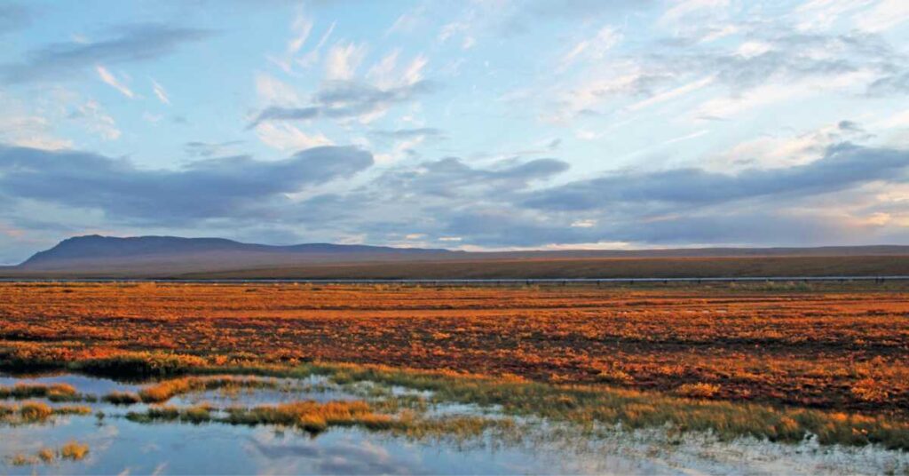
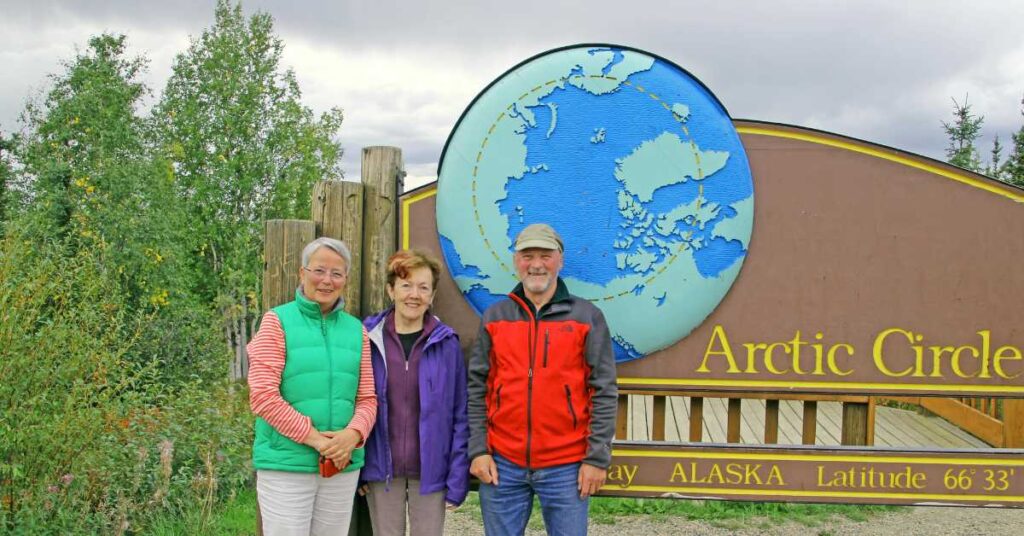
Riding Alaska’s Dalton Highway: Ice Road Trucking Before the Freeze We got to be Ice Road Truckers fans at my house, driving the Dalton with every episode. But I never thought, “Wow! I want to do that!” Sometimes, we’d joke about going to Coldfoot, just to cross the Arctic Circle, not that I had any idea what Coldfoot was like, or why you’d want to get that far and just stop. On the other hand, the idea of those 400-plus miles from Fairbanks to Deadhorse and Prudhoe Bay tucked itself away waiting for the right trigger. Like most of my trips, this one just came to me. I went in August when autumn had come to the Dalton and it was frosty in the Arctic. See “Riding the Dalton Highway: introduction and practicalities” too! The Dalton Highway – Just My Cup of Labrador Tea! The Dalton Highway – the Haul Road – is not for people who close their eyes when they get scared, so I looked for the best way to get to Prudhoe Bay without having to drive myself. I booked a three-day, two-night ride with 1st Alaska Outdoor School. There were three of us passengers – me along with seasoned world travelers, caravaners and campers Ulrike and Bernhard from Germany – and Matthew our guide and driver, an old hand at driving the Haul Road who had also worked at the oil fields. Over four hundred miles each way of two-lane dirt and gravel, potholes, washboard and steep grades. Fifty mph at the fastest. And there’s the special mud. Our driver Matthew told us the state puts calcium chloride on the road in summer to keep down the dust, but when it rains – and we had some drizzle and rain – the calcium chloride turns the road into thick goo. It was like thick dun-colored cake batter and it stuck to everything it touched. Special Dalton mud The Dalton starts just under 90 miles north of Fairbanks, following the Alaska Pipeline, which is the road’s reason for existing. The road was built for pipeline construction and then to serve the oil fields. Except for the old gold mining town of Wiseman (population about 14) the couple of places you can sleep started out as man camps during pipeline construction. As you approach the Dalton, you see the sign HEAVY INDUSTRIAL TRAFFIC PROCEED WITH CAUTION. Then, ALL VEHICLES DRIVE WITH LIGHTS ON NEXT 425 MILES. There’s a pullout near the start, a photo op, and a place to mark your real beginning. A beautiful truck pulled in for a stop, all chrome and orange. We talked to the driver’s wife who was along on the trip to keep him company. It’s dangerous, takes all your attention, but gets boring making that 800-plus mile roundtrip day after day. On a steep haul a little farther along, the guardrail was smashed. Matthew said that four days earlier a truck had gone over the side. Driver was OK. Truck totaled. Wrecks happen and don’t always turn out as well for the driver. A mere 80 or so miles later we crossed the legendary Yukon River. We stopped at the riverbank camp (good to know: flush toilets) and walked down to the river. I put my hand in. Silty and cold. Wide and fast. This is it, the mighty Yukon. Before the bridge that now carries the pipeline and trucks, I understand that truckers drove down the bank on a steep road to a ferry. It doesn’t bear thinking about. Then, mountains, ridge after ridge into the distance. Birch trees. Chilly. We stopped at another pullout and met a man riding the Dalton on his Kawasaki. His riding partner’s bike had broken down – we had seen it going south on a pickup truck earlier. He talked to Ulrike and Bernhard about his German heritage and said he lives and works in Peru’s Amazon jungle. A man who relishes extremes. The Arctic Circle And finally, not yet half way to Deadhorse, the Arctic Circle – the most popular photo op on the Dalton, I expect – and then Coldfoot Camp. Sleeping at Coldfoot is possible. There’s the old man camp. But Ulrike, Bernhard and I spent the night in Wiseman after dinner at Coldfoot Arctic CircleCamp truck stop. Along the way we met a couple from Hong Kong who were in Alaska for a long stay and driving the Dalton themselves. There are so few places to stop that we saw them three times. The last time, we ate together at Coldfoot, feeling like old friends now. Wiseman. Wiseman (population about 14) had been a gold-mining town around turn of the 20th century. It had stores and a post office that opened in 1909 and closed in 1956. The old post office is half sunken into the ground, which happens when you warm the permafrost. Ulrike, Bernhard and I shared the 2-bedroom Koyukuk cabin. We made tea and shared provisions in the morning before heading back south a few miles for hot food at Coldfoot. There was no food ahead for us for 240 miles if we kept going north. In the Arctic Circle On to Deadhorse, Day 2 The Koyukuk River was speeding around tight curves in its shallow bed. Fog hung across the road that morning. Koyukuk, then towering rock formations, the pipeline with golden birch and dark spruce in the middle distance, mountains beyond. We entered “the world’s largest municipality,” the North Slope Borough, and stopped at a pullout at Chandalar Shelf, a long, tortured grade cut into a mountainside, to view the mountains and peer over the steep unguarded drop off. It looked like thousands of feet down to me. Could have been. While we were stopped, a single semi slowly climbed the mountain. We took pictures. Spoiler alert – it was the same truck I rode in the next day! Atigun Pass. If you watched Ice Road Truckers, you’ll remember the Atigun Pass. A cut
Riding Alaska’s Dalton Highway: Ice Road Trucking Before the Freeze Read More »